 Every year, the UK magnetism community gets together at a conference to showcase the most recent advances in the field, establish collaborations and discuss (sometimes heatedly) new projects and findings.
This year, Magnetic Interactions, was hosted by the Lancaster Environment Center. They certainly did a great job! An interesting program of talks was put together, alongside a good poster session and an excellent curry for dinner!
All of us at Liverpool Geomagnetism attended the conference, with much of our recent work on display (more on that later). Labs from other Universities were represented too, including Oxford, Imperial, Plymouth, Leeds and Cambridge. Talk and poster topics ranged from discussion on geomagnetic excursions and jerks, through nanopalaeomagnetism and magnetic tracing of particulate pollutants.
Work from other labs
For the most part, the attendees are based at UK Labs, but this year, the invited speaker was none other than Ted Evans (University of Alberta, Canada) who gave a very interesting talk on what he has called the cryptonchron enigma. So what is a cryptonchron? It is described as a tiny wiggle seen in the Geomagnetic Polarity Time Scale (GPTM) which is smaller than the major chrons, a small feature of dimensions on the scale of:40-80nT, 10-20Km. Their underlying cause is currently unexplained, although recent studies suggest they might be attributed to short reversal periods or intensity fluctuations of the geomagnetic field (Boulingand et al. 2006). But the enigma remains: what are cryptochrons? With his collaborator G.Hoye, Ted has developed a computer model which calculates the magnetic anomaly over a section of oceanic crust. The output of this model suggests that cyptochrons could be considered subchrons which could indicate that the field might be reversing more regularly than was previously thought.
A pick of other interesting talks and posters included: Sarah Dodd (Imperial) & Conall Mac Niocaill, (Oxford), who propose that magentostratigraphic data can help in understanding the eruption rate and exact chronology of Large Igneous Provinces (LIPs), which a particular focus on the Etendeka Flood Basalts of Namibia. Richard Harrison, from Cambridge, presented his new approach to palaeomagnetic measurements, where the source of uncertainty introduced during bulk rock measurements, is removed by performing paleomagnetic measurements at sub micron length scales, in what is being called: nanopalaeomagnetism. One of the hosts, Barbara Maher talked about how magnetic particles found in particulate pollutants which accumulate on tree leaves allows monitoring of pollution in urban areas.
What the Geomag Lab has been up to
As I mentioned earlier, the Liverpool Geomagnetism Lab had a strong presence at the conference:
• Andy gave a talk in which he discussed the findings of his recently published article in Nature Geoscience were he and his collaborators link long term variations of the geomagnetic field to whole-mantle convection processes.
• I also presented the latest findings of my research on Archean age rocks of the Barberton Greenstone Belt. Combined with data previously published by Andy (Biggin et al. 2011), I’ve been able to constrain the age of the magnetic signal recorded in the rocks of the Hooggenoeg Formation, to 3.2Gyr.
• Emma Hodgson has been researching non-ideal behaviour in interacting single and multi-domain grains, using synthetic magnetic samples. She presented a poster with experimental results from her recent work which indicates that there is violation of Néel’s Laws of thermoremanent behaviour in interacting single domain samples.
• Wilbor Poletti (a visiting student from the University of Sao Paulo, Brazil) has compared classical Thellier-Thellier(TT), Triaxe (TR) and Microwave (MW) methods for determining palaeointensities using Brazilian baked clays. In his work, he has improved the experimental protocol for the MW method. He also shows that the MW method is significantly affected by the “cooling-rate effect” and a pseudo-single domain bias, but these are easily accounted for, performing an experimental correction, which means all three methods for determining palaeointensities are now comparable.
• Keeping with the paleointensity theme; Megan (who also contributes to the blog) has been working on determining the past geomagnetic field intensity using Turkish pottery fragments has found that, as is well known, experiment success rate is very variable. Putting aside methodology issues, she discussed other potential issues e.g. dating uncertainty, pottery compositional variability and kiln design.
• Andy also presented the PINT database (which has been recently updated with 227 new records taken from 14 references) with the aim to reach a consensus on what the properties of the most reliable paleointensity measurements are.
• In his work, Andreas Nilsson, has used data from the Pint database, using archaeological artefacts/lavas and lake/marine sediments, has constructed a new continuous spherical harmonic model for the geomagnetic filed over the past 9000 years.
• Finally, Neil has been questioning if how we calculate pole positions (from Fisher distribution statistics) is actually the best way to go about things? He proposes a new method which defines the virtual geomagnetic pole (VGP) from the expectation of angle between VGP and spin-axis of the Earth, adopting a spherical exponential distribution. This method consistently gives confidence limits that are smaller than those derived from Fisher, yet more likely to contain the true pole position.
The conference was a huge success. The conference organisers did a brilliant job, and it provides a great platform for us all to showcase the best of our work. Already looking forward to the next one – Cambridge here we come!
Sorry about the lack of posts in recent times. Here at least is what I’ve been busy with…
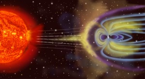 Often, as an undergraduate geology student, my lecturers referred to the past as the key to the future. This was never an easy concept to grasp. However, a recent article in New Scientist magazine (13th September 2011 ) really puts the research, we are doing, at the Palaeomagnetism Laboratory in Liverpool into perspective. Understanding how a large solar storm would affect satellites is important, and even more important is learning what we can do in order to minimise the disruption and damage caused by one. The Earth’s magnetic field protects us from the effects of solar storms and acts as a shield against the charged particles referred to in the New Scientist article. Understanding how the Earth’s magnetic field has behaved in the past is a useful tool in trying to understand how it might behave in the future. This ties in with Andy’s post back in June 2011: “Why should the taxpayer fund palaeomagnetic research?” This is a true example of how our work can contribute to modern society and highlights why the past is the key to the future!
One of the main parts of my Phd project is to collect the samples on which I am going to carry out the bulk of my experiments. Whilst so far I have been very lucky to have had samples to work on, donated to me by a number of colleagues, the time came when I needed some samples to call my own. I also felt that reading about my field area in journals was interesting, but, as many geologists will confirm, you need to visit your study area (field area) to fully take ownership of your research project.
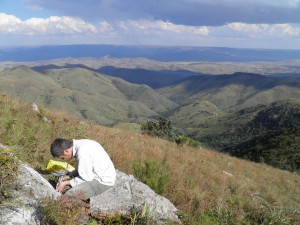
So, in May 2011, Andy Biggin and I embarked on an adventure to sample some of the oldest rocks in South Africa. We traveled to Badplaas in the northeast of the country, which along with the larger Barberton (to the north), serves as the gateway to the Barberton Greenstone Belt. At our accommodation, we met up with Prof. Marteen de Wit (AEON), who has been working in the area for over 30 years, and, as you can imagine, has become quite an expert in the geology of the belt.
Prior to the trip, and as a result of work carried out by myself, but in most cases by others (Biggin et al 2011; Tarduno et al. 2007 & 2010; Usui et al. 2009; and Yoshihara & Hamano, 2004); Andy and I had identified areas that we wanted to target for sampling. The first order of business during the field work was to find places where we could reach the outcrop – which we would then drill. Palaeomagnetists can sometime be thought of as lazy when it comes to field work: in order to drill a locality we carry a large amount of equipment, so walking for kilometers to get to an outcrop is not really an option (unless the outcrop is truly unique!). Therefore, finding tracks to get to the outcrop became just as important as finding the outcrop itself. To that end, we spent the first few days, with Marteen as an excellent guide, hunting down the best spots for sample collecting.
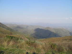
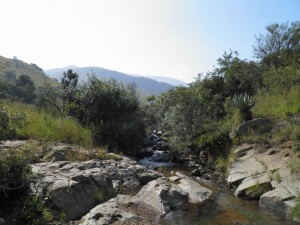
The reconnaissance was fun, exciting and sometimes a little challenging! I was the designated driver of our large 4×4, and not having driven off road prior to this trip, the first ford crossings, steep uphill climbs and U-turns in VERY small tracks were interesting to say the least. Nevertheless, we found some excellent localities to sample, surrounded by beautiful scenery.
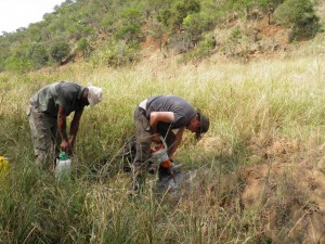
Next, I had to get to grips with our drill and learning how to orient the samples we collected. Geomagnetic samples are, for the most part, collected with a portable drill with a water cooled corer, which is diamond tipped. The drill is used to obtain a rock core which should be roughly 10cm long, although this varies depending who drills the core and how good they are at drilling (we discovered that Andy is far better at this job than I am).
Before removing the core from the outcrop, its orientation within the outcrop must be accurately measured. This is done by slipping an orientation device (we used a sun compass and magnetic compass) over the core and measuring the inclination (dip) of the core axis and then using the sun and magnetic compasses for determining the azimuth of the core axis (Butler, 1992). Making detailed notes of the geology and field relationships in my field notebook was another of my main tasks on the trip.
The trip was a success; we collected a large amount of samples, which now means I have a lot of work at the lab carrying out experiments. Working in South Africa was filled with amazing experiences such as: knowing that about 100m downstream of where we were working, there was a family of hippos; or encountering black rhinos at the end of a very long day; or knowing that I was sitting on some of the oldest rocks in the world!!! In truth, this post could have filled many, many pages, as there are so many anecdotes that I could tell about a long, but very productive trip.
This summer Laura Roberts and I headed across the pond to the Institute for Rock Magnetism (IRM) at the University of Minneapolis to attend the first ever Summer school in Rock Magnetism course being held there. We hoped this course would be useful as we both came to geomagnetism from Geology and have sometimes found our PhD’s a little overwhelming! The course itself was fascinating and covered a wide variety of topics: hysteresis, paleointensity, fine particle magnetism, remanent magnetisations to name but a few! The day was split into morning lectures which started at 8.30 (we didn’t even have a kettle available to make this early start more bearable!) followed by laboratory exercises in the afternoon. These were fascinating as the emphasis at the IRM is different to that at Liverpool and the IRM focuses a lot more on low temperature experiments. This meant we got to use a variety of new (to us!) instruments such as an MPMS (Magnetic Properties Measurement System) and a VSM (Vibrating Sample Magnetometer).
The trip also enabled us to meet a variety of other PhD and masters students from across the world (there were 11 different nationalities making up the 25 students attending the course). This gave us a great opportunity to find out about others’ research and to talk to those at a similar stage in their careers and learn how research is done at other labs. It was reassuring to know that we weren’t the only ones who felt a little confused by it all at times! We also learnt about the differences in how masters degrees and PhDs are awarded in other countries.
As part of the summer school, we were split into five groups of five, to undertake group projects, which, we worked on in the afternoons after lectures, in the lab. I found this part of the summer school very enjoyable. Each group worked on different sample types and it opened my eyes to the range of applications geomagnetism has. The aim was to characterise the magnetic properties of each group of samples. We worked on soil samples from a soil pit on University grounds; on dust samples collected in pollution monitors across Minneapolis; as well as on sea floor basalts from Iceland and the Mid Atlantic Ridge; and volcanic tuff samples from the Tiva Canyon (Yucca Mountain) in Nevada. After 7 days of experiments and hard work putting together and interpreting our results, each group gave a presentation to the rest of the class.
On our free weekend we went on a local fieldtrip which was really interesting and we visited some amazing, large glacial potholes in the Minnesota Interstate Park along the St Croix River. These potholes have been dated to the last glacial period when a torrent of water flowed south as the glaciers melted, carving the St Croix river. Where sand and gravel were caught in eddies or whirlpools in this fast flowing glacial meltwater they eroded the basalt host rock so quickly a vertical shaft was formed. There are more than 80 of these potholes in the Glacial Gardens in the park which is the greatest concentration of them in the world.
We both had a great time at the school and learnt a lot. Although unfortunately I still think we have a lot more to learn before we finish our PhD’s!
For more information and photos from the summer school see: http://www.irm.umn.edu/IRM/ssrm2011.html
Recently, I was casually asked by someone at a gathering whether any of the research I did was of use in the “real world”. The questioner was of course alluding to differences they perceive between “pure” and “applied” science and, in particular, to the issue of whether my research was of any direct practical benefit to human society. It was a fair question. The UK taxpayer funds my entire salary as well as the costs associated with my research (from overheads charged by the university for use of their buildings to flights to and from conferences and field areas). What’s in it for them?
Certain applications of palaeomagnetism are of direct practical use to society. For example, in dating past volcanic eruptions and measuring the emplacement temperature of lavas and pyroclastic flows, they can help in assessing volcanic risk. Palaeomagnetism can also help determine the tectonic stability of whole regions, assessing their suitability as depositories for high-level nuclear waste for example.
Nonetheless, most of the research projects I am involved with and indeed, most palaeomagnetic studies undertaken around the world, are purely “academic”. That is to say: they are not specifically aiming to achieve anything other than an increase in knowledge for its own sake. A common misconception is to think that this is the same as saying that they are of no practical benefit whatsoever. That is definitely not the case.
The main reason why practically all first-world nations invest in “blue skies” research is that they realise it pays dividends. Pure science, done well, contributes to a body of knowledge that, down the road, is the fuel for the innovations and improvements that we generally consider to be increasing civilisation.
By providing quantitative evidence for continental drift and sea-floor spreading, palaeomagnetic studies done back in the 1950s and 1960s played a crucial role in the acceptance of the theory of plate tectonics, first amongst Earth scientists and then by the public at large. This unifying theory now provides the underlying framework for, more or less, the entire subject of geology. How does the taxpayer benefit from funding this research more than 50 years ago? Materially, by the provision of cheap hydrocarbon and mineral resources that are found using models based on the plate tectonic paradigm. Bodily, by the much improved understanding of seismic and volcanic risk provided by the theory. Intellectually, by the awareness of this simple and beautiful aspect of our planet’s behaviour, now and for the last few decades, taught to every child in school (under the guise of “geography”, tragically).
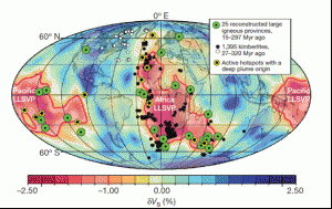
So, palaeomagnetism had its moment of glory, but how about since then? Well, it continues to contribute to a body of knowledge about our planet and its history which is increasingly important to human society as it struggles to deal with global environmental change and resource depletion. To cite a recent example, Torsvik et al. (2010) used a plate motion reference frame based on palaeomagnetic data to show that most of the Earth’s diamond deposits occurred above the margins of large seismic structures visible at a depth of nearly
2900 km. As well as potentially being of fundamental scientific importance in linking surface geology to whole mantle convection processes, the study will also serve to guide prospectors in the search for future sources of diamonds (which don’t just make pretty jewellery).

Understanding the Earth’s magnetic field is also a smart thing for us to be investing in. The geomagnetic field performs a valuable service to humans in shielding technology on the Earth’s surface and in orbit around it from much of the torrent of charged particles sent
our way by the sun. From studying palaeomagnetic records, we now have evidence suggesting that the field has been weakening for around the last 2,500 years. Will it continue to do so requiring the makers of satellites and power-grids to invest in better protection from the solar wind in the future? Only by better documenting and understanding past geomagnetic variations will we be able to answer this question with any confidence.
Personally, I am convinced that the Earth sciences are poised for another big step forward in the coming decade, perhaps the biggest since the plate tectonic revolution. Studies of seismology, mantle and core convection, geodynamo behaviour, and plate tectonic history are on the brink of coming together into an interpretable whole. The result will be an overarching theory of planetary evolution that palaeomagnetism will play a crucial and fundamental role in formulating.
For me, you can’t get much more “real world” than that.
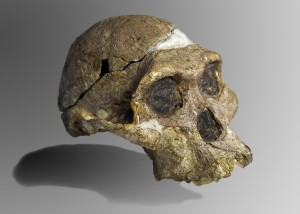
I first went to South Africa after finishing my undergraduate degree in 1997. The site that I visited was the Makapansgat Limeworks in the Limpopo Province of northern S. Africa. The site is world famous as one of the palaeocave deposits from which the early human species Australopithecus africanus has been recovered. The most complete cranium of this species is Sts 5, also known as Mrs Ples (although it is probably a young male), from the site of Sterkfontein, near Johannesburg. At the time of my first trip in 1997 I had wanted to undertake an MSc in Biological Anthropology and spend my life studying such skulls which I have always found fascinating. However, I was convinced on that trip by my soon to be supervisor that I should instead get into the buisness of studying rocks and caves. Being a caver with the Liverpool University Potholing Club and at the time being rather obsessed by caves it was not that difficult to twist my arm. So I started out undertaking a study of the stratigraphy and site formation of the Makapansgat Limeworks site and this led to starting a PhD on the magnetostratigraphy of the site and soon after on Mrs Ples and the Sterkfontein caves.
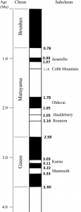
The age of hominin fossils such as Mrs Ples can be estimated by measuring the direction of magnetic minerals preserved in cave sediments and speleothem (stalagmites and stalactites). The Earth’s magnetic field currently runs from north to south, which is known as a NORMAL field state. However, at various times throughout Earth’s history the field has reversed by 180 degrees in what is known as a REVERSED field state. The timing of such major field changes is pretty well known for the last 7 million years (Ma) (the time-scale of human evolution) based on studies of sea floor spreading zones, where these changes are recorded like a bar code, and radiometric dating of volcanic rocks. This bar code of field change is known as the Geomagnetic polarity Time-Scale or GPTS. All rocks contain some form of magnetic mineral. The direction of the Earth’s field is preserved in cave sediments when water flushes these sediments into pools of water. When the sediment settles out of suspension in water the magnetic minerals orient themselves to the contemporary magnetic field. The sediments then become compacted and cemented, preserving the magnetic field direction. By measuring sediments in caves and comparing the polarity with the GPTS the age of the sediments, and therefore the fossils within them, can then be determined.
This type of work is not undertaken in caves very often because caves can have extremely complicated depositional sequences, which are often relatively short when compared to open landscape volcanic sequences in places such as East Africa. The sediments will often only record a single polarity that could be fitted to any one of the NORMAL or REVERSED polarity periods (Chrons or SubChrons). However, if the cave sediments contain fossils the polarity to which the cave record relates can be established by considering the general time range of the fossils found within the sequence. The resultant palaeomagnetic age is often more refined than the age range for the fauna alone. In some cases a radiometric age (like radiocarbon dating, although this method is of little use when compared to magnetostratigraphy because it does not date material older than ~50,000 years. I once read in the Lonely Planet Guide to South Africa that the Makapansgat Limeworks was dated using radiocarbon to 3 million years ago!! quite a feat given this upper age range) can provide a start point to tie in the magnetostratigraphy of the section. In East Africa this is easy as volcanic material exists which can be dated using Potassium-Argon Dating. In South Africa however, no volcanic material exists in the caves and so no radiometric ages were available to date the deposits until recently.
The solution to this problem at Sterkfontein, and particularly relevant to Mrs Ples, is that some very rapid reversals of the Earth’s magnetic field also occur (perhaps as rapid as 6,000-18,000 years long) and these are sometimes recorded in the sequences because the cave sediments are deposited so slowly over a short time period. At Sterkfontein the Mrs Ples fossil was deposited at the same time as a speleothem (like a stalagmite) layer which records two of these short polarity events. This allowed the age of the deposit containing Mrs Ples to be estimated to between roughly 2.16 to 2.05 Ma, around the time of the Reunion and Huckleberry Ridge geomagnetic field events. This was much younger than originally expected (>2.6 Ma). This age has since been confirmed by the successful uranium-lead dating of part of the same flowstone to around 2 Ma. Some fossils of Au. africanus at Sterkfontein are dated to as old as 2.6 Ma and others from Makapansgat may be as old as 3.0 Ma, however, Mrs Ples is currently the youngest known example at ~2.1 Ma and may very well represent the last of his species. Whether Mrs Ples is our direct ancestor……….well, that’s another story.
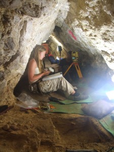
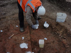
taking samples from archaeological excavations at the rear of a constricted cave passage in South Africa
To many researchers the word ‘Archaeomagnetism’ is synonymous with Archaeomagnetic dating. i.e. using small changes in the secular variation of the Earth’s magnetic field to date burnt structures and artefacts (see Neil’s post on the 16th February). However, this is just one of a range of studies that can use magnetic methods of analysis to reconstruct and understand archaeological deposits or artefacts. I am one of the few geomagnetists whose undergraduate background is in archaeology, rather than physics, geophysics or geology. As such, I consider myself as much an archaeologist as a geomagnetist and I believe passionately about multi-disciplinary work and interaction of researchers. I also believe that modern archaeology is a science conducted predominantly in the field or the laboratory and driven by rigorous scientific analysis and hypothesis testing. My interests are not primarily in understanding the origins of the Earth or how and why the magnetic field changes but how humans evolved both anatomically and behaviourally.
To try and gain a unique perspective on these issues I use magnetic methods of analysis to improve the chronological framework of human evolution, to reconstruct the early human use of fire and to reconstruct the palaeoclimate in which humans were living. Magnetism is an extremely versatile and underutilised resource in archaeology in that it can help archaeologists answer a range of different questions, if only they knew to ask, or if only geomagnetists knew that archaeologists wanted to know the answer to such questions. Done correctly, archaeomagnetism in its broadest sense can be a symbiotic relationship between the two disciplines where geomagnetists get answers about the behaviour of the Earth’s magnetic field through time and archaeologists learn, not only the age of their sites, but the heating temperature of their hearths and kilns; their atmosphere of heating or fuel source; whether campfires were used once or multiple times; if ancient humans heated their artefacts to change their properties for some purpose; and much much more. As with everything in life communication is the key. Ask not only ‘what can Archaeomagnetism tell us?’ but ask ‘can we solve this problem using Archaeomagnetism?’ and the answers might surprise you! ……..it always surprises me.
One of the most fascinating questions in geomagnetism concerns the strength of the Earth’s magnetic field. It is well-known (by those who know it well) that the direction of the field varies with time. You can see an estimate of how it is changing locally by looking at an OS map. These give the magnetic variation and the rate at which it changes each year, which is important if you are navigating with a magnetic compass. The strength of the field also varies from place to place and changes over time too, but you won’t notice this because it is pretty tricky to actually measure it. So tricky in fact that it wasn’t until the 1830s that the great mathematician and physicist C.F. Gauss, came up with a method for measuring the field strength. He did this by a crafty arrangement of magnets , suspended by torsion threads. In recognition of this great achievement, the units of magnetic flux density are called Gauss. (Actually, these days we tend to use the SI equivalent , the Tesla, named after another giant of electrodynamics. No need to feel too sorry for Gauss – he still has the ubiquitous Gaussian distribution, a celebrated theorem in vector calculus and a whole host of other mathematical machinery named after him).
The really interesting thing is this: ever since Gauss first measured the strength of the field, it has been dropping. Over the 170 years or so since the first measurements, the main field has decayed by some 8 or 9% and this has led to all sorts of speculation as to whether we are heading for some big geomagnetic event, like a reversal. It is true that this is quite a large drop- if the geodynamo suddenly stopped the field would only decay quite slowly- about 1% per century- but it is also likely that this sort of variation is not uncommon. The big question is how long was this going on for before people were first able to measure it?
To try and estimate this we have to use things like archaeomagnetism. In my last post I talked about how it was possible to use the direction of the “fossil magnetism” in heated archaeological structures to estimate the date at which they were fired. Well, it is also possible to estimate the strength of the field at the time they were fired, although the method is fraught with difficulties. People often use sherds of pottery of known date for this sort of work. Quite a lot of data has been amassed over the years, with over 300 “archaeointensities” spanning the period 1600-1840. Most people think that there is little evidence to suggest that there was any great drop in the field strength over this period.
I’ve always found this a bit unlikely. It just seems to be too much of a coincidence that the long term trend in the behaviour of the field changed at just the time we started measuring it. I’ve been looking at all the available data again, and I think there is evidence of a trend showing that the present decay has been going on since before 1700. The results of my analysis have just been published in Earth and Planetary Science Letters. So, I would argue that it seems likely that the Earth’s magnetic field has dropped by about 15% since 1700, but I think the arguments will go on for some time yet.
One resource that might help to resolve this issue with more certainty is the experiments carried out by Alexander von Humboldt, Major Edward Sabine and others. These people made a great many observations of the strength of the field, over the period from 1790s to 1830s, by timing the oscillations of a magnetised needle. Unfortunately this only gives us relative field strength: they were able to show that the field is stronger at high latitudes than it is at the equator, but they were unable to put absolute values on their measurements. It was an incredible scientific endeavour, with such names as Captain Fitzroy of the Beagle, the botanist David Douglas and the Arctic explorer Captain James Ross all taking sets of magnetised needles all over the globe. Sabine’s own account of this project, published in 1838 is is available online.
 While Andy has been looking at some of the oldest rocks on Earth, some of us have been concentrating on more recent history. Studying the Earth’s magnetic field by the remanent magnetisation of archaeological artefacts is called archaeomagnetism. Here at Liverpool, we are always keen to hear from archaeologists who have uncovered burnt structures such as hearths or kilns. If we can take orientated samples back to the lab, we can tell what direction the magnetic field was pointing in when the feature last cooled down, “freezing in” the magnetisation. Not only can we use this information to see how the Earth’s magnetic field has evolved over time, once we have a good idea of how the field changed it is possible to give a date for the burning of the feature. We call this archaeomagnetic dating.
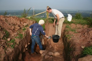
Here are a couple of sites that we looked at recently. Eddisbury hillfort in Cheshire was being excavated as part of the Habitats and Hillforts project being run by Cheshire West and Chester Council. The feature was above the hillfort’s ramparts, but below what looked like a Medieval field boundary. Archaeomagnetically, we think it’s probably from the 9th C.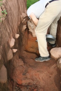
This one was in Mildenhall, Suffolk, where excavations were being carried out prior to the building of a new supermarket. It’s a circular feature , about 2m across, with flints and river pebbles forming the edge, but it’s not clear what it was used for. There was little dating evidence on site, although there was Roman pottery from contexts above the feature. Archaeomagnetically, we thought it was Middle Iron Age, probably from the 4th C BC. Our models don’t let us date features much older than this, but as we collect more data, it may become possible.